


WinGPS™ Marine

WinGPS™ Marine ၏ ရွင္းလင္းခ်က္
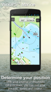
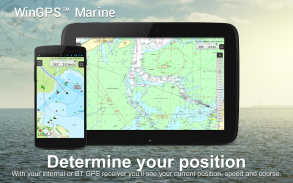
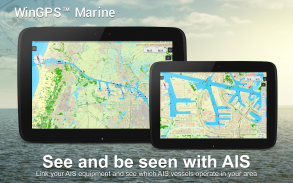
WinGPS Marine သည် သင့်အား အန္တရာယ်ကင်းသော ခရီးစဉ်အတွက် ခေတ်မီပြီး လွယ်ကူသော လမ်းကြောင်းပြကိရိယာများကို ပေးပါသည်။ သင်၏လမ်းကြောင်းကိုဆွဲရန် ဇယားပေါ်တွင် ကြာကြာနှိပ်ပါ။ လေယာဉ်ပေါ်ရှိ GPS သည် သင်၏တည်နေရာအတိအကျကို ပြသပေးမည်ဖြစ်သည်။ ဇယားများကို သင့်စက်တွင် ဒေါင်းလုဒ်လုပ်ပြီး နောက်ဆုံးပေါ် ဇယားများဖြင့် အော့ဖ်လိုင်းတွင် လှေစီးလိုက်ပါ။ သင်၏ AIS ကို WIFI မှတစ်ဆင့် ချိတ်ဆက်ပြီး ဖြစ်နိုင်ခြေရှိသော ယာဉ်တိုက်မှုများကို ကာကွယ်ပါ။
ရွက်လွှင့်ခြင်းနှင့် စက်တပ်ရွက်လှေများ၊ ကုန်းစောင်းများနှင့် ကနူးလှေများအတွက် Stentec မှ တီထွင်ထုတ်လုပ်ထားပါသည်။ လှေငှားရန် သို့မဟုတ် စင်းလုံးငှားသည့်အခါ သင့်တော်သည်။
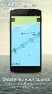
• ကုန်းတွင်းဇယားများအတွက် အနောက်ဥရောပနှင့် Donau အတွက် ရေလမ်းအတွက် တံတား၊ သော့ခလောက်များနှင့် ရေလမ်းအချက်အလက်များပါရှိသည်။ ဤအရာဖြင့် သင်သည် မည်သည့်အတားအဆီးကိုမဆို ညွှန်ပြနိုင်ပြီး သင့်လမ်းကြောင်းများကို လျင်မြန်စွာ ချိန်ညှိနိုင်သည်။ သင့်ခရီးစဉ်အတွင်း ရေလမ်းနှင့် အကွာအဝေးများ၏ အမည်များကို ပြသပါမည်။
• အကောင်းမွန်ဆုံးဇယားပုံတစ်ပုံအတွက် စမတ်ကျကျတံဆိပ်များထပ်နေသည့်စာသားအညွှန်းများ (ရေလမ်းကြောင်းဖြင့်) တားဆီးပေးသည်။ တံတားနှင့် လော့ခ်ချခြင်းဒေတာကို Course Up လှည့်ခြင်းဇယားများတွင် အမြဲဖတ်နိုင်ပါမည်။
ပေါ်လွင်ချက်များ
• Stentec၊ Imray၊ NOAA နှင့် Delius Klasing တို့၏ နောက်ဆုံးပေါ်ဇယားများပေါ်တွင် လမ်းညွှန်ခြင်း။
• ကားချပ်သိုလှောင်မှုအတွက် SD-ကတ် ပံ့ပိုးမှု။
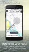
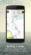
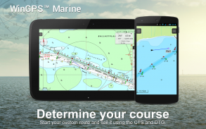
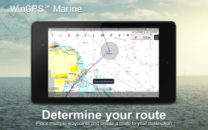
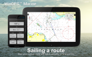
• လမ်းကြောင်းများ၊ ဇယားများ၊ လမ်းကြောင်းများနှင့် လမ်းကြောင်းများကို စီမံပါ။
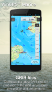
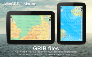
• NOAA World GRIB-ဖိုင်များ- လေ၊ လေဖိအား၊ မိုးရေချိန်နှင့် အပူချိန်။
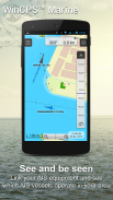
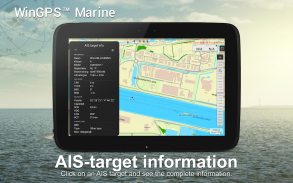
• ကြိုးမဲ့ WIFI သို့မဟုတ် Bluetooth ချိတ်ဆက်မှုမှတစ်ဆင့် AIS နှင့် GPS ကို ချိတ်ဆက်ပါ။
• AIS သင်္ဘောများ၏ အရှိန်အဟုန်ဖြင့် တိုက်မိခြင်းများကို ကာကွယ်ပါ။
• Man-overboard ခလုတ်သည် ပျောက်ဆုံးနေသော သင်္ဘောသားများကို ပြန်လည်ရယူရန် ကူညီပေးသည်။
• ဇယားသည် ဗဟိုပြုထားသော GPS အနေအထားအောက်တွင် ရွေ့လျားသည်။ NorthUp၊ CourseUp (Marine) သို့မဟုတ် HeadUp (Plus)။
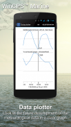
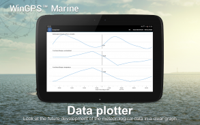
• အသေးစိတ်ရာသီဥတုခန့်မှန်းချက်များနှင့်အတူ Harmoniemodel KNMI (ထို့အပြင်၊ နယ်သာလန်သာ)
• ပင်လယ်ပြင်တွင် NOAA လှိုင်းခန့်မှန်းချက် (ထို့အပြင်၊ ကမ္ဘာတစ်ဝှမ်း)
WinGPS Marine ကို ပထမဆုံးအကြိမ် ထည့်သွင်းသောအခါ၊ ၎င်းသည် အကန့်အသတ်ရှိသော လုပ်ဆောင်ချက်များဖြင့် WinGPS Marine Lite ဖြစ်လာမည်ဖြစ်သည်။ GPS ပံ့ပိုးမှုဖြင့် ဇယားကြည့်သူအဖြစ် စံပြဖြစ်သည်။
အက်ပ်အတွင်း ဝယ်ယူမှု
WinGPS Marine ကိုဝယ်ယူပြီးနောက်၊ သင်သည်သင်၏ကိုယ်ပိုင်လမ်းကြောင်းပြစနစ်၏စွမ်းဆောင်ရည်အပြည့်ကိုသော့ဖွင့်လိမ့်မည်။ ယခုအခါ သင်သည် လမ်းကြောင်းများကို ရေးဆွဲနိုင်ပြီဖြစ်ပြီး GRIB ဖိုင်များကို ဒေါင်းလုဒ်လုပ်ကာ ယခင်သီချင်းများကို သိမ်းဆည်းကာ AIS နှင့် GPS တို့ကို ချိတ်ဆက်နိုင်ပြီဖြစ်သည်။ ခန့်မှန်းထားသော လေ၊ မိုး၊ လေဖိအားနှင့် AIS ပစ်မှတ်များကို ကြည့်ရှုရန် လွယ်ကူသော အချိန်ဇယားကို အသုံးပြုပါ။
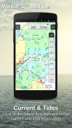
WinGPS Marine Plus အဆင့်မြှင့်ခြင်းဖြင့်၊ သင်သည် ဘုတ်အဖွဲ့ PC၊ multiplexer သို့မဟုတ် AIS transponder သို့ ကြိုးမဲ့ချိတ်ဆက်မှုမှတစ်ဆင့် အပိုဘုတ်တူရိယာများကို ချိတ်ဆက်နိုင်မည်ဖြစ်သည်။ သင်၏ဒေတာကြံစည်မှုတွင် လက်ရှိနှင့် ဒီရေလှိုင်းအချက်အလက်များကို ပြသနိုင်သည် သို့မဟုတ် ဇယားတွင် ၎င်းကိုကြည့်ရှုနိုင်သည်။ ထို့အပြင်၊ အဆင့်မြင့် KNMI ၏ Harmonie ရာသီဥတုပုံစံကိုလည်း ကမ္ဘာတစ်ဝှမ်းရှိ NOAA လှိုင်းများကို ထောက်ပံ့ပေးထားသည်။
KUSTFIJN Getijmodel Rijkswaterstaat သည် Waddenzee၊ Ijsselmeer၊ Markermeer၊ Randmeren နှင့် Zeeland ပေါ်ရှိ ရေစီးကြောင်းများ၊ ဒီရေနှင့် ရေအဆင့်များကို မှီခိုပြီး နှစ်ရက်ကြာ လေတိုက်သည့် ခန့်မှန်းချက်ဖြင့် KUSTFIJN Getijmodel Rijkswaterstaat။ အနက်ရောင်မျဉ်းများသည် လေကြောင့် အတိမ်အနက်၊ ဒီရေနှင့် သွေဖည်မှုပေါ်မူတည်၍ ဘေးကင်းသော ရေလမ်းများကို ကန့်သတ်ထားသည်။
ဇယားကွက်လွှမ်းခြုံမှုနှင့် ဇယားများကို တပ်ဆင်ခြင်း။
WinGPS Marine ကို စတင်သောအခါတွင် ESRI ၏ (အွန်လိုင်း) မြေမျက်နှာသွင်ပြင် ပုံသေဇယားကို အလိုအလျောက် မြင်တွေ့ရပါမည်။ US ၏ NOAA ဇယားကိုလည်း ဖွင့်နိုင်ပြီး Chart Manager မှတစ်ဆင့် အခမဲ့ကမ္ဘာ့ဇယားကို ဒေါင်းလုဒ်လုပ်နိုင်ပါသည်။
ဘေးကင်းသော လမ်းညွှန်မှုအတွက်၊ သင်သည် www.stentec.com တွင် ဒစ်ဂျစ်တယ်ဇယားများကို ဝယ်ယူနိုင်ပါသည်။ အက်ပ်ရှိဇယားများကို သို့မဟုတ် Google Play™ မှတစ်ဆင့်လည်း ဝယ်ယူနိုင်သည်။ သင့်ဇယားများကို မတူညီသော စက် ၃ ခုတွင် ထည့်သွင်းနိုင်သည်။ ဥပမာအားဖြင့်၊ သင်၏ Android တက်ဘလက်၊ ဖုန်းနှင့် Windows လက်တော့ပ် သို့မဟုတ် ကွန်ပျူတာတွင်။
Marine အက်ပ်တွင် သင်၏ Stentec အကောင့်ဖြင့် ဝင်ရောက်ပြီး သင်၏ဝယ်ယူထားသော DKW2 ဇယားများကို Chart Manager တွင် ဒေါင်းလုဒ်လုပ်ပါ သို့မဟုတ် အပ်ဒိတ်လုပ်ပါ။
ဥပမာအားဖြင့်၊ အပတ်စဉ် BaZ အပ်ဒိတ်များနှင့် အပတ်စဉ် အပ်ဒိတ်များဖြင့် လူကြိုက်များသော DKW1800 စီးရီးများ။ ကျွန်ုပ်တို့၏အွန်လိုင်းဆိုင်သည် Donau အပါအဝင် အနောက်ဥရောပနိုင်ငံများ၏ ကုန်းတွင်းဇယားများနှင့် နောက်ဆုံးပေါ်ပင်လယ်ဇယားများကို ပံ့ပိုးပေးပါသည်။
နောက်ထပ် အချက်အလက်-
www.wingpsmarine.com
ကိုယ်ရေးအချက်အလက်မူဝါဒ:
www.stentec.com/en/en/privacy-statement
အသုံးပြုသူများ ထည့်သွင်းမှု
အက်ပ်၏တိုးတက်မှုအတွက် ကျွန်ုပ်တို့သည် သင်၏အတွေ့အကြုံနှင့် အကြံပြုချက်များကို အလွန်စိတ်ဝင်စားပါသည်။ helpdesk@stentec.com သို့ အီးမေးလ်တစ်စောင် ပေးပို့ပါ။
WinGPS™ Marine - ဗားရွင္း 4.75
(31-03-2025)
WinGPS™ Marine - APK သတင္းအခ်က္အလက္
APK ဗားရွင္း: 4.75package: com.stentec.wingps_marine_liteWinGPS™ Marine ၏ ေနာက္ဆုံးဗားရွင္း
အျခား ဗားရွင္းမ်ား


က႑တူအက္ပ္မ်ား

သင္ႏွစ္သက္ႏိုင္သည္မ်ားမွာ...


